We originally planned this trip for the fall of 2019. I had cataract surgery so we put it off until the fall of 2020. Well, Covid put a stop to that trip. Then we decided in the fall of 2021 that we needed to do the northeast U.S. trip before we got any older, knowing it would be a hard, month-long trip. So, here we are in the spring of 2022 and the trip finally became a reality!
Day 1 - Tuesday, April 17, 2022
We got away at 6:10 a.m. and made it as far as Oklahoma City for lunch. We had planned to go as far as Woodward, Oklahoma that day and take in a couple things there. We went to the Plains Indians and Pioneer Museum and Boiling Springs State Park.

State #2

We saw lots of wind farms

Plains Indians & Pioneers Museum

Interesting - nothing was wasted

More uses for buffalo parts

Sod house in Oklahoma in 1907

Woodward Tornado - April 9, 1947

Who knew you could write a check for 8 cents?

Woodward, OK
The Boiling Spring


We ate dinner at Ramiros Mexican Restaurant and stayed at the Super 8.
Day 2 - Wednesday, April 20, 2022
Conrad wanted to drive out through the Oklahoma Panhandle because we'd never been there before. Plus, he wanted to see Optima "Lake" that was being built about the same time as Waurika Lake. We drove through lots of high winds and the area was so dry. We passed through Slapout, OK (slap out in the middle of nowhere) and it was just a gas station. Our first stop of Optima Lake. We had trouble finding the dam since it was closed to traffic in 2009. The lake was designed to contain a maximum of 618,500 acre-feet of water, the lake never reached more than 5% of its capacity and remains effectively empty. It was really interesting to see where the "lake" was. We had to drive down a "Road Closed" road to get to the dam. The wind was about 50 mph or more! The only "water" in the lake was a small area of gray mud.

Not much to look at in western Oklahoma!

More nothing!

Looking for the lake!

Everywhere was dry and dusty.

We found the lake! They were pumping oil here.
You can see the intake tower in the background. All
of this area was to be under water.

The intake tower next to the dam.

You can see the wet mud in the background.
There was a small amount of water, too. We saw
a few mule deer walking around out here.

I think Conrad was thinking about climbing over
the gate! This is the road that used to go across
the dam.

The dam road is closed!
Our next stop was Black Mesa State Park and Black Mesa Nature Preserve. It is in the very northwest corner of the Panhandle. We drove through the state park first and then through the nature preserve. We saw lots of mesas and beautiful scenery. We ate a picnic lunch near the trail to the top of the tallest mesa but didn't hike up there. It was 4.2 miles one way and we had places to go! We did spend some time talking to a couple who had just finished the hike and they showed us some pictures from the top. They lived in an RV fulltime and were trying to visit as many "highest points" in each state as they could.

We did a lot of windshield farming along the way!

Black Mesa Nature Preserve
.jpg)
Open range through the preserve. We saw lots
of cattle through here.

Wild turkeys

Some of the mesas along the way.

How mesas are formed

The tallest point in Oklahoma is at the top, left
side of this mesa. It is 4,973' high.

State #3
We had reservations in Raton, New Mexico to spend the night. Our GPS (car and phone) would not take us the way we wanted to go so we settled for the old paper map! There sure wasn't much traffic on this stretch of about 58 miles. Somewhere along the way, we saw a sign that said "Gravel Road Next 17 Miles"! The gravel road was not on the map! It must have not been a heavily traveled road and the pavement had gotten so bad, they just put down gravel. We could only go between 30 mph and 45 mph but the road wasn't too bad. We saw some beautiful mesas and the first 50 miles we only saw 1 vehicle, a UPS truck!. The last 8 miles we saw 3 more cars. There were a lot more free range cows through here. We also had 7 pronghorn cross in front of us. We finally made it to Raton and stayed at the Super 8 here. Conrad enjoyed watching the ravens flying around here.
Day 3 - Thursday, April 21, 2022
We left the hotel at 7:30. Instead of taking the interstate from Raton to Pueblo, CO we detoured on to Highway 12 in Colorado. We had gone that way with Clyde and Sandy in 2007 and it was a beautiful drive and we wanted to do it again. It was a gorgeous, sunny day.

Near Folsom, NM

Near Des Moines, NM

Raton, NM - The wind was a real challenge!

State #4

Trinidad, CO

Coming in to Trinidad, CO

Cokedale, CO - The Cokedale Coke Ovens
Coke is used to refine and smelt iron.

Giant mounds of coal (a slag pile). They look like
black dunes.

Near Weston, CO - The snow covered mountains
were beautiful! I couldn't get enough pictures through
here!

Near Weston, CO

Quaking aspens near Cuchara, CO

Near Cuchara - I love the contrast of colors!

Beautiful mountain lake

We found snow on the ground near Cuchara!

Cuchara Pass - elevation 9,995'

La Veta - a radial dike
After our gravel road adventure yesterday plus all the dust and wind, we needed to find a carwash. We found an old one in Walsenburg and stopped there. I insisted on doing the washing. There were chunks of concrete missing and as I was hurrying, I stepped on a crack that also had a hole near it and fell. I hurt my hand and Conrad finished rinsing the car and he took over driving. On the way to Pueblo, my right thumb was swelling and hurt pretty bad. We had planned to stop in Pueblo to walk along the River Walk on the Arkansas River and to eat lunch. I had one of the hand braces with me so I dug it out when we stopped and put it on. Luckily, it would fit either hand. A doctor visit was not on the itinerary so we carried on. I figured I had pulled a tendon in my thumb.
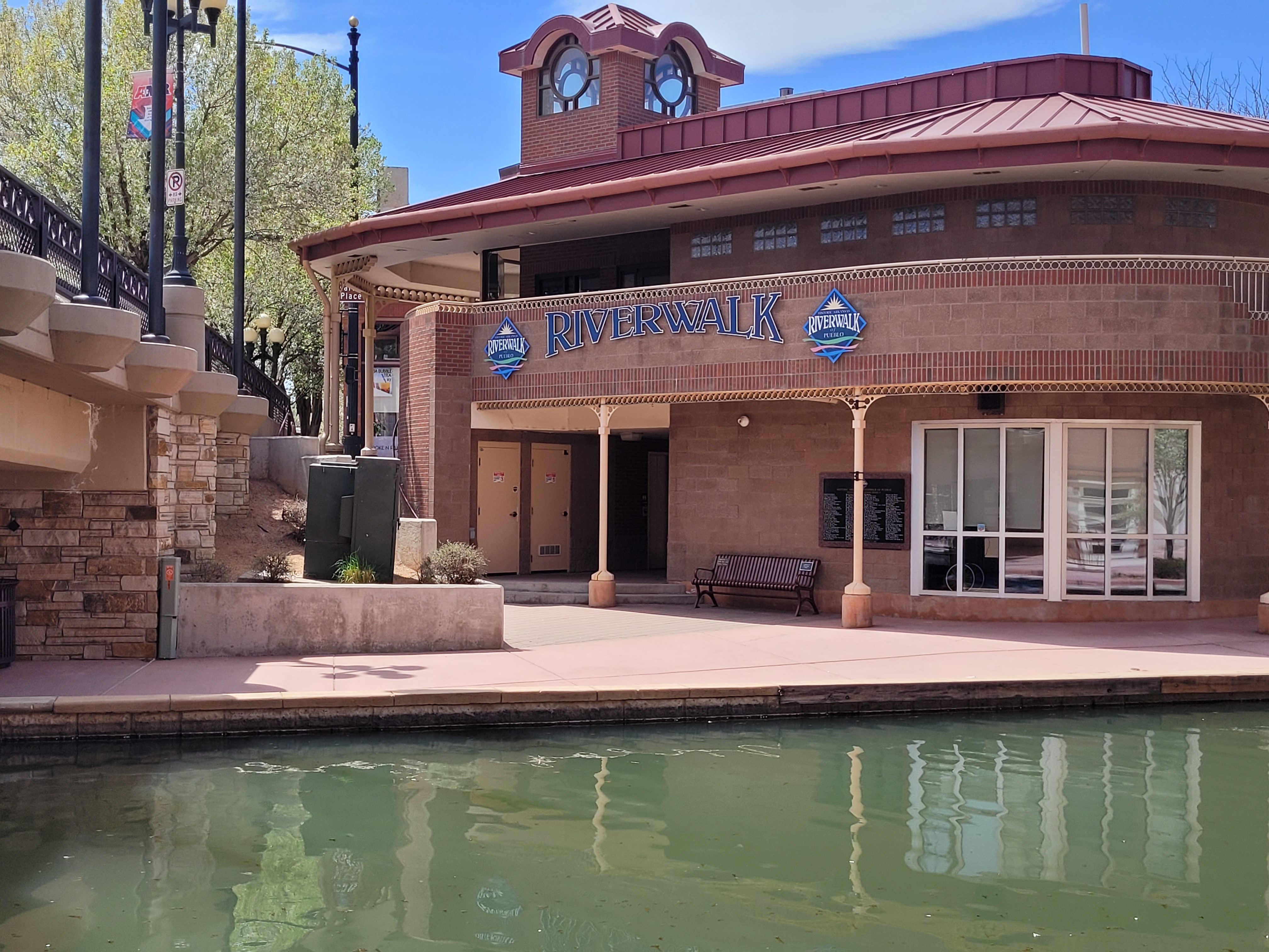
Entrance to the River Walk

Our lunch view along the River Walk at
1129 Spirits and Eatery

Along the River Walk

Interesting - a trail used for cattle drives
in the late 1860s.

Map of the trail

Riverside Building, Pueblo
Built in 1890 - The front features Italian carvings.
There is red limestone on one side of the building
and red brick on the other 3 sides.

Riverside Building
Day 4 - Friday, April 22, 2022
It took us awhile to get ready this morning since Conrad had to fix my hair for me! That was an interesting experience! I can't use my right thumb at all and I have a brace with a thumb stabilizer on it. But, we just rolled with it and had a few good laughs. Royal Gorge didn't open until 10:00 so we left the hotel at 8:00. Canon City is known as the "Prison Capital of the World" because of the 13 correctional facilities in the area. Skyline Drive was built in 1906 by convict labor. It is a 3-mile stretch of road that follows the crest of an 800-foot-high Dakota hogback. We drove along Skyline Drive and made a few stops along the way.

The view from Skyline Drive

The view from Skyline Drive

Skyline Drive is a one-way road.

The view from Skyline Drive

One of the trails on Skyline Drive

We climbed to the top of this trail.

Skyline Drive
The Arkansas River is the sculpting force of the 1,200-foot deep Royal Gorge. The bridge is one of the highest and most famous suspension bridges in the world. We rode the gondola across the gorge but skipped the ziplines and other wild activities!


A view of the area and the bridge
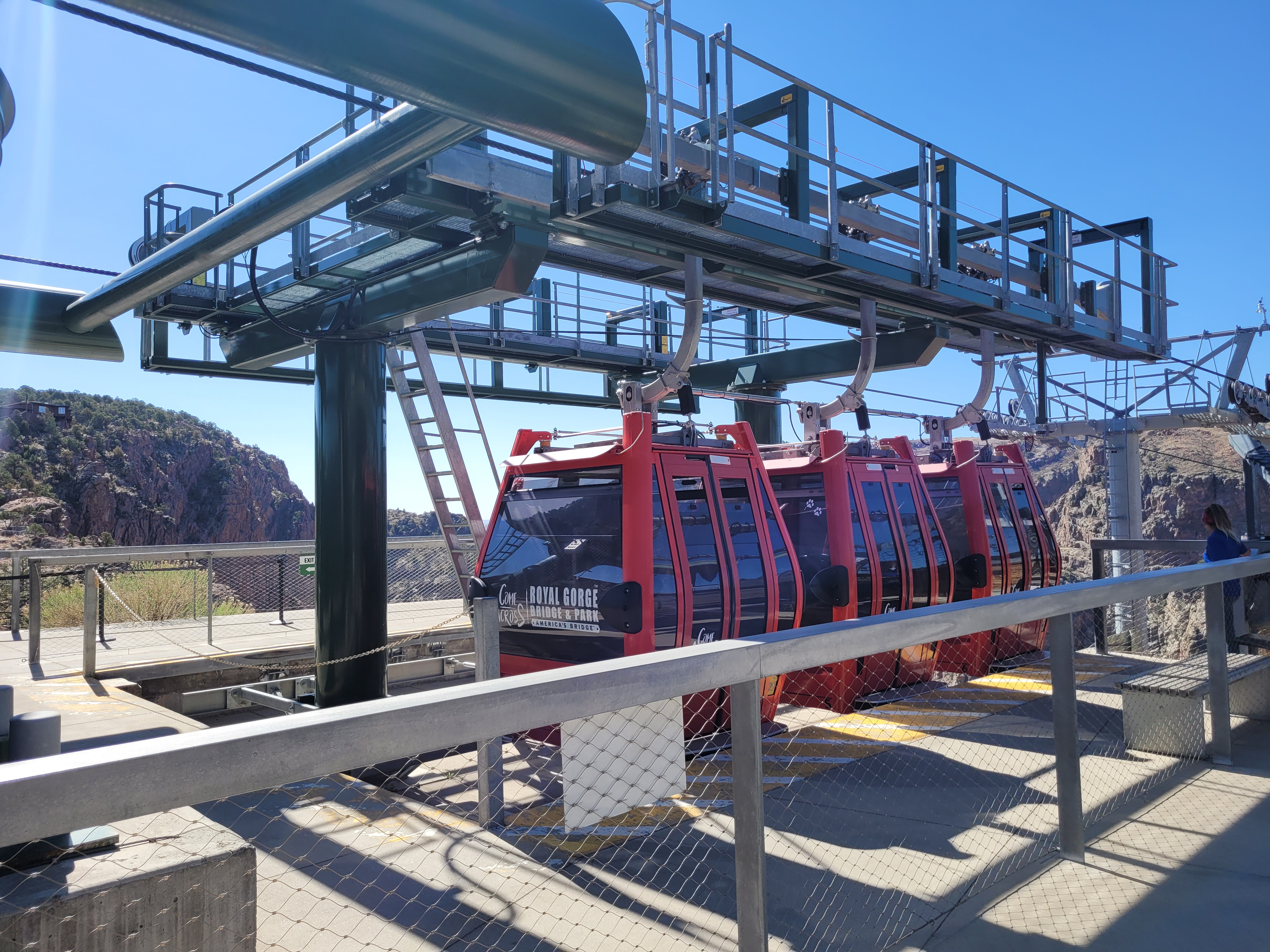
We were the first and only people to cross the gorge
on the gondola this morning.

The view of the river from the gondola.

The bridge

The bridge - This is just a pedestrian bridge
but there were construction workers driving
across it.
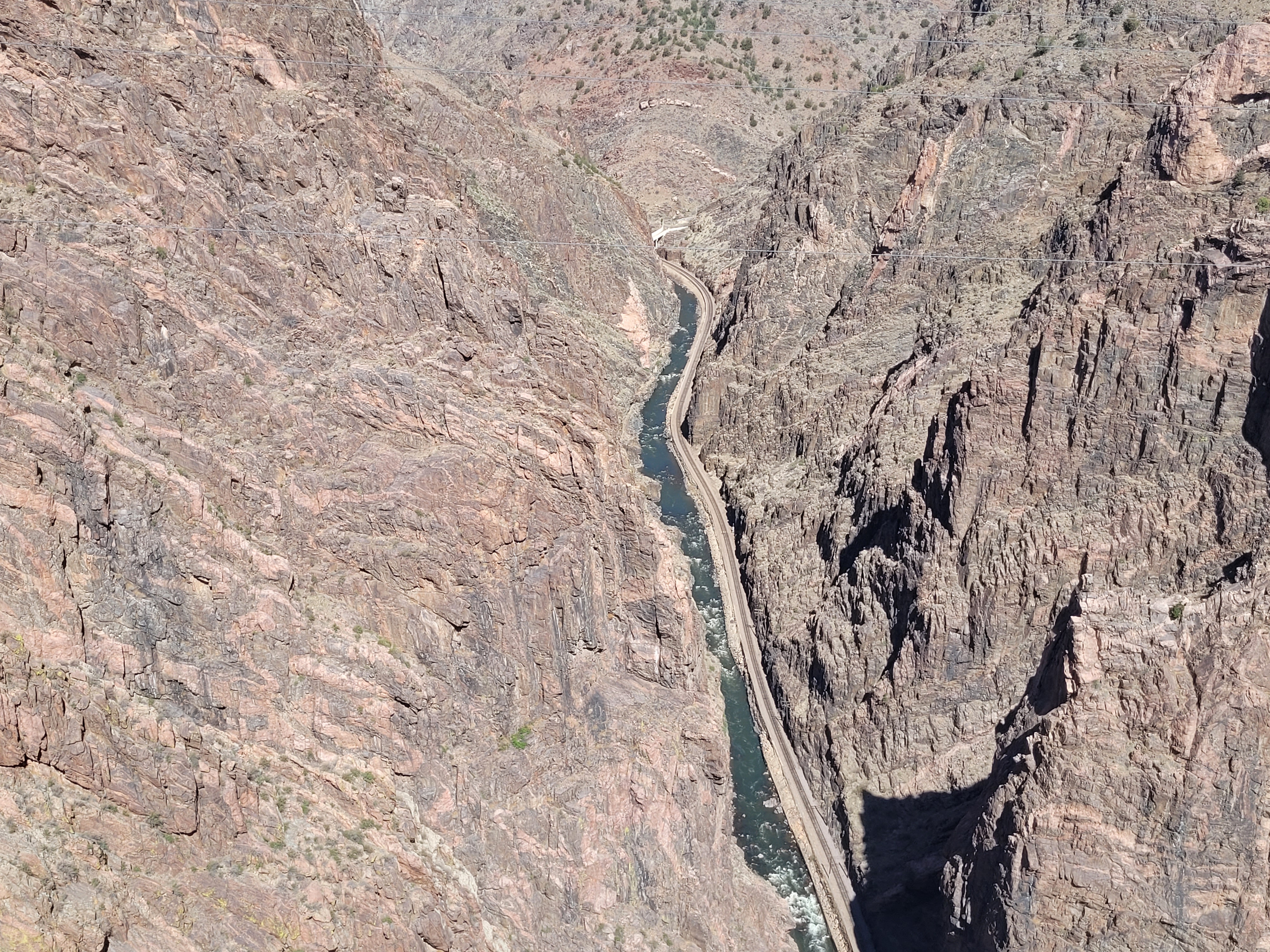
The Arkansas River

It takes lots of cable to hold up this heavy bridge.
It's just over 1,200 feet across.

Conrad is standing beside the Arkansas flag.
It was so windy up there he had to carry his hat!

Sangre de Cristo Mountains
Our next stop was in Salida. Jason had told us it was fun to watch the kayaks on the Arkansas River. He also wanted us to buy him a new hat! Driving through downtown Salida, there were deer in a lot of the yards. Some people had put up privacy fences in the front yard to keep the deer out. The river area was really nice and the temperature was in the 60s. We ate lunch at Soulcraft Brewing Company.

Deer grazing in the yards in Salida

Arkansas River in Salida - Paddleboarder, rafters
and fishing. We watched for about an hour.

We saw lots of these warnings in Colorado.

Approaching Monarch Crest - The Continental
Divide runs through here. Driving up the steep mountain,
we were only getting 17 mpg!

The gift shop at Monarch Crest - elevation 11,312
Thanks to some prescribed medicine before we left home,
I didn't have any trouble with breathing in the high altitude!

Parking lot at the top of Monarch Pass

The snow was still piled high this high up!
Our main concern was to get to Gunnison, CO since there was snow in the forecast and we wanted to be off the mountain. We had some light rain about 4:30 and the temperature was 29 at Monarch Pass so we felt we were OK. Lucky for us, it held off and we made it to Gunnison by 5:15 p.m. We stayed at the Gunnison Inn at Dos Rios. Supper was from our snack supply, in the room. There were snow flurries after we arrived at the hotel but it seemed to melt right away.
Day 5 - Saturday, April 23, 2022
We didn't leave the hotel until 8:45 this morning. We had a leisurely breakfast at the hotel then on to Black Canyon of the Gunnison National Park. It was a real overcast day and we were disappointed we didn't get to see it with the sun shining bright. It was still awesome though. We walked to all but one of the viewpoints. Some were slick with snow so it was slow walking. It cleared briefly in the afternoon so we did see some of it with the sun shining. I'd love to go back here on a good day.

Blue Mesa Reservoir near Gunnison

Blue Mesa Reservoir is Colorado's largest reservoir
and hit its second-lowest level on record for the
end of August, 2021. Everything out this way is so dry.

Blue Mesa Reservoir - Dillon Pinnacles

The road in to the park

The road in to the park
The South Rim Drive at Black Canyon of the Gunnison National Park is 7 miles long and has 12 overlooks. The finlike rock formations in the canyon are known as pegmatite dikes. This park has some of the steepest cliffs, oldest rock and craggiest spires in North America. It became a National Park in 1999.

Here I am, standing in the blowing snow!

It snowed pretty hard for awhile. The
temperature stayed between 31* and 37* all day.
This is at one of the overlooks.

A view of the canyon from one of the viewpoints.
A video of the canyon from one of the viewpoints.

A view of the canyon from one of the viewpoints.

A view of the canyon from one of the viewpoints.
That's the Gunnison River.

One of the trails

A view of the canyon from one of the viewpoints.

Here we are!

A view of the canyon from one of the viewpoints.

Interesting comparison

A view of the canyon from one of the viewpoints.
Elk Mountains in the background.

A view of the Gunnison River from one of the viewpoints.

The last viewpoint. It was beautiful here.
We had eaten some crackers, etc for lunch along the way so we had a late lunch/early dinner about 4:00 at Horsefly Brewing Company in Montrose. Their motto was "No Crap on Tap"! Conrad found a beer he really liked and bought a 6-pack before leaving. We stayed at the Stay Wise Inn. On the way back to the hotel, we gassed up the car and had to wash it again. There was so much salt stuck to the car from our trip through the mountains that you couldn't use the backup camera, even after we tried cleaning them with Windex. So, we found another carwash but did a drive-through one this time! No accidents and the backup camera was good after that!
Day 6 - Sunday, April 24, 2022
We were figuring on a long day today so we left the hotel at 7:00 a.m. Our first stop would be at Colorado National Monument. If you're ever in northwest Colorado, this is definitely worth a visit! We really didn't know what to expect and were surprised that it was beautiful there! We ended up spending almost 3 hours here and had allotted only 2 hours! Towering monoliths exist within a vast plateau and canyon panorama. You can experience sheer-walled red rock canyons along the twists and turns of Rim Rock Drive. The Rim Rock Drive is 23 miles with lots of pull-outs to stop and explore.

Near Whitewater, CO

The following pictures are all from here.


Leaving Colorado - you can see the Utah sign on the left.

State #5
We decided to stay on I-70 for just a few miles once we entered Utah and then take Highway 128 south. We drive through the ghost town of Cisco, UT. The only thing here is a general store named Buzzards Belly. We didn't stop but we should have! We heard it was a great little store. Highway 128 runs along the Colorado River. The river was so dirty and moving so fast. We saw some speed boats racing down the river. The first stop along here was at Dewey Bridge.

The Colorado River along Hwy 128

The Dewey Bridge was built in 1915-1916. Before it was
destroyed by a brush fire in 2008, it was the longest
suspension bridge in Utah. At the time of its construction,
it was the 2nd longest suspension bridge west of the
Mississippi. It is one of only 3 bridges spanning the Colorado
River in Utah even though the river runs for 400 miles through
the state. The bridge had been replaced with a new one in 1988.

Along Hwy 128

Highway 128 along the Colorado River
Video along Hwy 128
We hiked part way to Fisher Towers but the trail was pretty rough and rocky. It was a beautiful area and we ate a picnic lunch in the car here.


Fisher Towers

Fisher Towers

Fisher Towers

Fisher Towers

Fisher Towers

Fisher Towers and Linda

Fisher Towers
The La Sal Mountains are part of the Rocky Mountains and La Sal National Forest and are Utah's second highest mountain range. More than a dozen mountains in the range have peaks above 12,000 feet with Mt Peale the highest at 12,721 feet. The compact range is only 15 miles long and 6 miles wide.

We stopped at Red Cliffs Lodge near Moab. The ranch was settled in the late 1800s and has been a working ranch ever since. Inside the lodge is the Moab Film and Western Heritage Museum. Many films have been shot at Red Cliffs Ranch and displays and photos tell of the colorful cowboy life - past and present. We watched a video here about many of the films and commercials that have been shot here on the ranch and in the Moab area.

The museum

Just a few of the commercials shot in the area

Some of the MacGyver series were filmed here.

when their car drove over the cliff.


We were in the park from 7:00 a.m. until 4:30p.m. On our way out, we stopped by the Visitors Center for t-shirts, a park book and a couple other things and then headed back to the hotel. We were so tired so stopped to eat dinner on the way back at The Broken Oar. We had to wait a bit since they didn't open until 5:00. We had a great dinner then to the hotel. We were exhausted! I took a shower, loaded the pictures to the computer and went to bed. We logged 17,487 steps today!


Dinner that night was at the Moab Brewery. We also did a couple loads of laundry to get us through the rest of our trip.


 Green River Overlook
 Green River Overlook
 Green River Overlook - Cleopatra's Chair in background


 Whale Rock - That's Conrad on the right. He made

Information from Indiana Jones and the
Last Crusade movie shot here.

Along Hwy 128 near Moab
We spent 4 nights at Red Stone Inn. We had a really small room but it was livable! We had a little kitchen area that had a microwave, refrigerator, coffee maker and a sink. It was really quiet here but we didn't spend much time in the room. We ate dinner at the Moab Grill. We gassed up the car for tomorrow and had to pay $4.55 a gallon! The temperature only got up to 62* but felt warmer because of the higher altitude and it was sunny all day.
Day 7 - Monday, April 25, 2022
We got up at 5:00 to get ready to be at Arches National Park for our timed entry of 7:00 a.m. It was a great time to be there. When we got to the gate, there was only one car ahead of us at the pay station. We made a few quick stops because we saw some really cool stuff but everything we read said to head to Devils Garden at the back of the park first, before it got too crowded. Here we hiked to Pine Tree Arch, Tunnel Arch and Landscape Arch. That was about 2 miles total. Then we were off to all the other cool stuff. There were lots of people but it didn't feel crowded.

Welcome to Arches National Park

Just inside the entrance

Arches National Park

Looking back towards Moab

Arches National Park

Arches National Park

Here we are at Courthouse Towers

Arches National Park

Balanced Rock on the right

Arches National Park

Arches National Park

Devils Garden Trailhead

Devils Garden Trail

Tunnel Arch

Pine Tree Arch

Trail to Landscape Arch
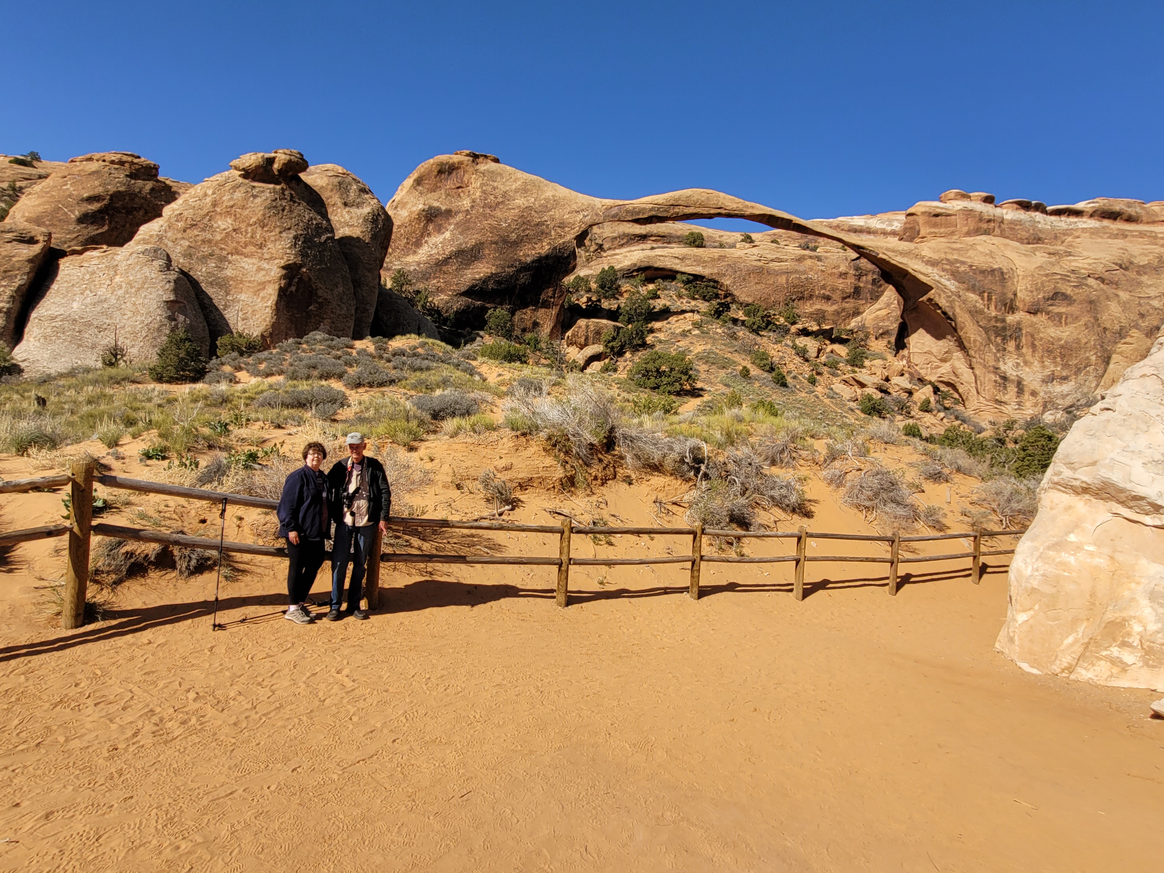
Landscape Arch

Landscape Arch

La Sal Mountains in the distance

On the trail to Tapestry Arch - We saw lots
of this all over the park.

Tapestry Arch

Skyline Arch

The trail to Sand Dune Arch was narrow in places
and the trail was sandy.

Trail to Sand Dune Arch - lots of kids here had
buckets and were playing in the sand.

Sand Dune Arch - we don't know who these
people were but there was a long line of people
waiting to get their picture taken. We just wanted
a picture of the arch!

Broken Arch

Fiery Furnace - An entrada sandstone maze in the heart
of the park. You have to take a guided hike or get a
permit. It's easy to get lost in here.

Fiery Furnace

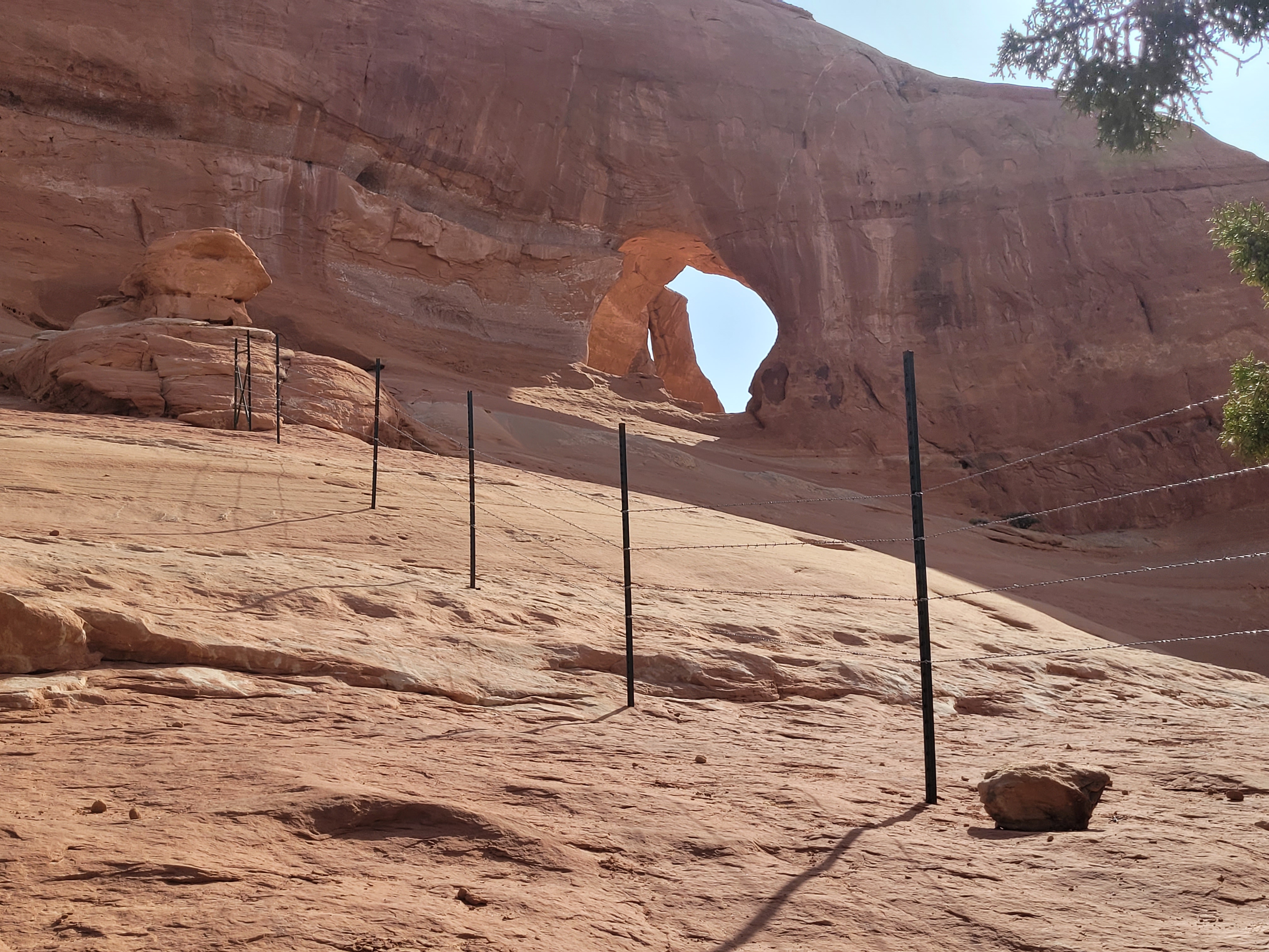
Delicate Arch - There are over 2,000 stone arches in the
park but this free-standing arch has become a widely
recognized symbol of the state of Utah and one of the most
famous geologic features in the world. The opening beneath
the arch is 46 feet high and 32 feet wide, making it the largest
free-standing arch in the park.

Arches National Park

South Window Arch

North Window Arch on the left and South Window
Arch is on the right.

Elephant Butte - Use your imagination and it looks
like an elephant! It is the highest point in the park.

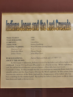
Double Arch - The arches were created from water
erosion from above. The bigger arch is 148 feet wide
and about 104 feet high. The arch was briefly visible
in the beginning of the movie Indiana Jones and the
Last Crusade.

Double Arch

Balanced Rock - The iconic tower sits 128 feet
tall and is composed of Entrada Sandstone top sitting
on a Dewey Bridge Formation pedestal. The different erosion
rates of the two types of sandstone are what created
Balanced Rock and what will ultimately be its demise.

Balanced Rock

Balanced Rock and Linda balancing
on a rock!

Petrified Sand Dunes

The La Sal Mountains...again!

Arches National Park

Park Avenue - Park Avenue is an area named for an
impressive, jagged wall, the profile of which reminded
observers of the NYC skyline.

Park Avenue trail
Day 8 - Tuesday, April 26, 2022
We left the hotel a little after 8:00 and drove south of Moab. Our first stop was Looking Glass Rock and Looking Glass Arch. We drove down another gravel road for what seemed like a long time but it was only about 2 miles. As we pulled up to the parking area here, there was a huge, loaded semi parked right in the middle of the road. We just sat a minute, not knowing what was going on and decided we could get around him on the passenger side. We just barely got past him. There was a family getting ready to rock climb there and Conrad talked to them. The truck driver was looking for Looking Glass Ranch. He ended up having to back up a little more than 1/2 mile. He had missed his turn. Someone from the ranch had come to show him the way. It was a neat arch and worth the trip there.

The gravel road to Looking Glass Rock & Arch

The semi that was lost!

You can tell from this advantage point that the
truck was definitely lost! This is in the middle
of nowhere!

Looking Glass Arch - the sun was
against us this morning!
Looking Glass Arch - so windy here

Looking Glass Rock

On the way to Needles Overlook

Needles Overlook Road

We saw a lot of these along the way.

So much sage brush and then a tree in the
middle of nowhere!
The Needles are composed of Cedar Mesa Sandstone (in the Cutler Formation). This layer was deposited about 225 million years ago as a coastal sand dune. Below the Cedar Mesa Sandstone lies the Paradox Salt formation. In subsequent eons, the underlying salt blocks collapsed, fracturing the landscape. Weathering along these fractures has produced the intricate spires and needles for which the area is named.

Needles Overlook

Needles Overlook


You can see two isolated sandstone buttes called
South Six Shooter and North Six Shooter. These spires
were named by early cowboys for their resemblance to
pistols. The Six Shooters are remnants of Wingate Sandstone,
their dark red pedestals are composed of Organ Rock shale
and Cutler Sandstone. The surrounding stone has eroded
away, leaving the Six Shooters aiming towards the sky.

The trail at the overlook

Needles Overlook

Needles Overlook

Needles Overlook

Love the layers of rock at the overlook.

Conrad climbed to the top of this petrified
sand dune. Then we just decided to eat lunch in
the car here.

There were a lot of these "caves" along the road
to Needles Overlook.

It was pretty windy and it was so dry out here.

Wilson Arch - The formation is known as Entrada
Sandstone. Over time the superficial cracks, joints,
and folds of these layers were saturated with water.
Ice formed in the fissures, melted under extreme desert
heat, and winds cleaned out the loose particles. Wind and
water attacked these fins until, in some, the cementing
material gave way and chunks of rock tumbled out. Many
damaged fins collapsed, others, with the right degree of hardness
survived despite their missing middles like Wilson Arch.

Wilson Arch

The north end of Wilson Arch - notice the layers
of rock.
I was pretty excited to tour the Hole N' The Rock house. It's a quarter of a mile high and a mile around the base. Years ago, it was hollowed out into a houseful of rooms. It is a 14-room, 5,000 square foot house gouged out of a solid red sandstone monolith. It began as a small cove hollowed out of the rock to serve as a bedroom for the settler's five boys. It was those boys who spent a large portion of their lives enlarging the cove into a house. One room at a time, they pursued their project until the end result was a 14-room house complete with a natural rock fireplace vented with a chimney bored through the rock from the top down.
About 1944, Hole N' The Rock Diner opened. One room was painted to control the sand, and outfitted for a kitchen. Another room became the dance floor. The kitchen included a hand-made concrete deep-fat fryer with a removable iron pot insert. An innovative bath was devised from a metal stock watering tank, cemented and waterproofed, complete with taps and running water. After the diner closed, a rock and gift shop was added and the family began charging 50 cents for tours of the house. The rooms had no doors, but the rock pillars left for support provided a degree of privacy.
The Hole has a constant temperature of 65 to 70 degrees, so a heating system is not needed. On chilly days, however, a blazing fire in the huge rock fireplace looks cozy. The fireplace is credited to Leo and Clarence, who hauled a drill to the top and bored two 1-" diameter holes 60 feet down through a shell of the rock formation for a fireplace vent. It was a bullseye! The holes were in the exact location to provide a very workable chimney, a feat that amazes engineers visiting the Hole today.

Hole N' The Rock

The owner, Albert Christenson was a great sculptor.

The house - the gift shop is through the large white
area. You can see some other white walls to the right
of it that are windows in the house.

This "Jeep" was parked out front of the gift store.

The wheels

There was also a bull.
Dinner that night was at the Moab Brewery. We also did a couple loads of laundry to get us through the rest of our trip.
Day 9 - Wednesday, April 27, 2022
We left the hotel about 7:15 and headed to the Island in the Sky area of Canyonlands National Park. It took us about an hour to get there after stopping several times for pictures.

On the way to Island in the Sky

On the way to Island in the Sky

On the way to Island in the Sky - had to
let the cows cross the road!
Island in the Sky, the name given to the elevated northern section of Canyonlands National Park, is almost precisely that; an isolated piece of land far above the deep canyons of the Green and Colorado Rivers. This narrow "peninsula in the sky" was, in fact, carved by the two great rivers as they flowed ever closer to their confluence at Cataract Canyon. The Island in the Sky mesa rests on sheer sandstone cliffs over 1,000 feet above the surrounding terrain.

Canyonlands National Park - Island in the Sky area

The road in to the park

Island in the Sky area

Grand View Point

Grand View Point

Grand View Point - Totem Pole in center

Grand View Point - Monument Basin

Grand View Point - Monument Basin

Grand View Point - Monument Basin

Grand View Point

Grand View Point

Grand View Point

Grand View Point

Grand View Point

Buck Canyon

Buck Canyon

Buck Canyon

Buck Canyon - Utah Juniper tree

Buck Canyon

Buck Canyon

Near Buck Canyon

Green River Overlook


Green River Overlook


Green River Overlook

Whale Rock - Couldn't get the whole thing in the picture!

the climb up there and said the wind about blew him
away. I didn't think I could handle the steep part.


On the way back to Moab

Shafer Overlook - This is the Shafer Trail Road. It is
a rough, narrow, steep, high clearance 4-wheel drive
road with sharp drop-offs. Our car couldn't make it!

Shafer Overlook
After leaving the park about 3:30, we had time to drive to Sego Canyon to see the rock art from several peoples: Fremont, Ute and Barrier-style. The information signs aren't there any longer so we didn't have much information. Barrier style are the oldest, dating back to 2000 BC, while the Ute style are the most recent, dating back to 1300-1600 AD. This was an area frequently inhabited by ancient people for thousands of years.

Rock art at Sego Canyon

Rock art at Sego Canyon

Rock art at Sego Canyon

Sego Canyon

Rock art at Sego Canyon

On the way back to Moab

The La Sal Mountains, coming into Moab
We rearranged things in the back of the car and packed all that we didn't need the next morning and loaded it up. I brought back half of my dinner last night so we shared that in the room (Chipotle Chicken Burrito with rice and veggie chili) and added some of our stuff we had taken. The temperature got up to 83* today.
No comments:
Post a Comment