We left the hotel at 7:10 a.m. and the temperature was 46*. We wanted to drive around and see some of Gallup. It's an interesting little town. There are lots of murals painted on the buildings. The city's mural painting tradition started in the 1930s as part of President Franklin D Roosevelt's Great Depression Work Projects Administration (WPA) program.

Gallup, New Mexico

Gallup, New Mexico

Gallup, New Mexico

Gallup, New Mexico

Gallup, New Mexico

El Morro Theater - Gallup, New Mexico

Gallup, New Mexico

Gallup, New Mexico
 Gallup, New Mexico

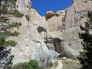
Our next stop was at El Morro National Monument, south of I-40. El Morro Monument is a sandstone promontory covered in the carved petroglyphs and painted pictographs made by centuries of travelers who stopped here to drink the water at the pool below the rock. Travelers left left signatures, names, dates, and stories of their treks. While some of the inscriptions are fading, there are still many that can be seen today, some dating to the 17th century. These included Native Americans, Spanish explorers, and the US Army Camel Corps, as well as pioneers heading west in the mid-19th century and railroad surveyors. We hiked the 1/2 mile Inscription Rock Trail.
While we were stopped to take a picture of the sign at the entrance, we met a nice couple from New Smyrna, Florida. We talked to them awhile and they were headed to Las Vegas then to Glacier Park. We each talked about where we had been and where we were going. We told them our next stop was the Bandera Volcano and Ice Cave. They had never heard of it. We walked out to our cars together and I showed them my pages on this. She took pictures of the pages with her phone and decided they were going there too.
While we were stopped to take a picture of the sign at the entrance, we met a nice couple from New Smyrna, Florida. We talked to them awhile and they were headed to Las Vegas then to Glacier Park. We each talked about where we had been and where we were going. We told them our next stop was the Bandera Volcano and Ice Cave. They had never heard of it. We walked out to our cars together and I showed them my pages on this. She took pictures of the pages with her phone and decided they were going there too.

On the road to El Morro

On the road to El Morro

On the road to El Morro

On the road to El Morro

On the road to El Morro

Entrance to El Morro National Monument

El Morro

El Morro

El Morro

 Inscription Rock Trail
 Inscription Rock Trail


 Petroglyphs
 E Penn Long's name
 More names

 P Breckinridge's name and others

Ramon Garcia Jurado Inscription
 Bighorn sheep petroglyph in middle of picture
 R H Orton's name and more petroglyphs
 More petroglyphs


A last look at the sandstone cliffs.
 Continental Divide in the Zuni Mountains


 Going up the trail
 The trail to the volcano
 More of the trail
 Cinders from the volcano

Looking down in the volcano
 My guy!
 The Ice Cave was amazing!
 Ice Cave - notice all the icicles!
 Over 20' of ice - so hard to imagine


 San Felipe de Neri Church
 San Felipe de Neri Church
 Old Town Plaza area


They had a nice Visitor Center but we decided to walk the trail first, before it got too hot.

Beginning of Inscription Rock Trail
Centuries of wearing away by wind and water have left their mark, rounding and smoothing once sharp and craggy edges. Minerals and microscopic life carried in by weather have added their touch to the palette, striping the bluff grey and green through years of accumulation.


Along the trail
For centuries people found their way here to drink from these reliable waters. There is no spring. The pool is fed largely by rainfall in July, August and September, and by melting snows. The black stripes that ribbon down the cliff face are the "spillways" where water from the bluff's top funnels into the pool. When full the pool is about 12' deep and holds about 200,000 gallons of water. The pool never empties but evaporation can shrink it from its banks until it is filled by precipitation.

Inscription Rock Trail

Inscription Rock Trail
Petroglyphs cover the sandstone bluff. Each group of travelers - American Indian, Spaniard and Anglo - left its mark in its own way. Petroglyph makers incised or pecked into the sandstone. They incised the petroglyphs by pecking into the rock using an animal antler or a harder rock called a hammerstone. Spaniards used daggers or horseshoe nails to inscribe their names and messages. Pioneers and other settlers along the trail of westward expansion probably used hammer and chisel, knives, nails or other tools.

E Penn Long of Baltimore, Maryland chiseled this elegant-looking inscription. Long was a member of a U.S. Army expedition led by Lt Edward F Beale to find a wagon route from Fort Smith, Arkansas, to the Colorado River. The group, which first passed by El Morro in 1857, was also testing the usefulness of camels in crossing the deserts of the Southwest.


P (Peachy) Breckinridge was the man in charge of the twenty-five camels used by Lt Beale in 1857. After his work with Beale, Breckinridge returned to his home state of Virginia and fought in the Civil War.


Many Spanish inscribers wrote "passed through here." The message below translates to: "On the 25th of the month of June, of this year of 1709, Ramon Garcia Jurado passed through here on the way to Zuni." From the time Ramon Garcia Jurado moved to New Mexico as a colonist in 1693 until his death at the age of 80 in 1760, he was witness and participant in the Spanish settlement of New Mexico. It is likely that he was on a campaign against the Navajos during his visit to El Morro in 1709.

Ramon Garcia Jurado Inscription
Notice the petroglyphs, particularly the bighorn sheep and the bear paw. Many petroglyphs depict animals that were once familiar fauna in the region. Their compelling shapes and actions invite us to pause and imagine why people may have pecked them into the bluff.

R H Orton is just one of many inscriptions along the cliff here. You can see a church, some stars, crosses, petroglyphs, and a cavalry flag. R H Orton became adjutant-general of California after the Civil War.


Some of the names with dates are done in blocks.

Leaving this area and heading to our next stop, we crossed the Continental Divide in the Zuni Mountains, very near our next stop. I don't know how many times we've crossed the Continental Divide on this trip but I know it is a lot!

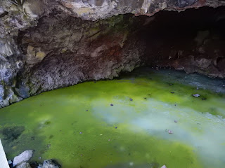
Our next stop was at New Mexico's Land of Fire and Ice - the Ice Cave and Bandera Volcano. Situated on the Continental Divide, you walk through the twisted, old-growth Juniper, Fir and Ponderosa Pine trees, over the ancient lava trail to the Ice Cave. Here the natural layers of ice glisten blue-green in the reflected rays of sunlight. Another trail winds around the side of the Bandera Volcano to view one of the best examples of a volcanic eruption in the country.
The Bandera Crater is the largest volcanic cinder cone in the region. It erupted around 10,000 years ago. There were two stages of the eruption: first the cinder cone developed, then a massive lava flow broke out this side. The molten lava reaches temperatures over 2,000 degrees. Bandera's lava flow is nearly 23 miles long. At the end of the eruption, the lava suddenly fell back down the main vent making the bottom of the cone deeper than the outside lava flow. This crater is nearly 1,200 feet wide at the top and roughly 750 feet deep. The elevation at the look out point is 8,122. Over time, erosion and gravity take their toll on the crater and it is slowly filling up as cinders and rocks fall down into it.


We decided to climb the trail up to the top of the volcano first, to get the hot part over! It was really warming up. We knew it would be cooler at the ice cave. It was quite a climb and the altitude was bothering me. Conrad wanted to turn back about the time we were getting close to the top because he was concerned about me. I had gotten that far and wasn't about to turn back!


Once we got to the bottom again, we rested a few minutes with a water break. Then it was on to the ice cave. This is what I really wanted to see.
Located in a section of collapsed lava tube, the Ice Cave is a unique combination of physical factors that have combined to form a natural ice box and has been accumulating ice for over 3,000 years. Inside the Ice Cave, the temperature never rises above 31 degrees and where natural layers of perpetual ice glisten blue-green in reflected rays of sunlight. We had to go down lots of wooden steps to get to the ice cave.


Ice cave
On the road back to I-40, we passed Mount Taylor. It is one of the great volcanic cones of the Colorado Plateau. Mount Taylor rises to an elevation of 11,301 feet and last erupted some 2 million years ago. Numerous fissure eruptions since that time and as recently as about 1,200 years ago have created lava flows that form malpais or badlands along sections of this road.

Mount Taylor
The next stop will be Albuquerque Old Town and will spend the night there.

Interesting cafe in Albuquerque
San Felipe de Neri Church is a historic Catholic church located on the north side of Old Town Plaza. Built in 1793, it is one of the oldest surviving buildings in the city. San Felipe de Neri was established in 1706. The original church building collapsed in 1792 after a heavy rain and was replaced by the current structure the following year. The towers were added in 1861, a parish school was constructed in 1878, and a convent for the Sisters of Charity was build on the west side of the church in 1881.


Old Town Plaza area

Old Town Plaza area
We ate dinner in Old Town at Hacienda del Rio. The food wasn't very good and the service was awful. When the waiter brought us our check, he told us we had to pay in cash because the credit card machine wasn't working. Someone was supposed to have told us when we came in but didn't. After that, we headed to the Ramada Mountain View. The cost was $65.67. We were worn out and had seen temperatures as high as 98 degrees. We walked 11,524 steps, 21 flights of stairs and drove 194 miles today.
No comments:
Post a Comment